-
>
湖南省志(1978-2002)?铁路志
-
>
公路车宝典(ZINN的公路车维修与保养秘籍)
-
>
晶体管电路设计(下)
-
>
基于个性化设计策略的智能交通系统关键技术
-
>
德国克虏伯与晚清火:贸易与仿制模式下的技术转移
-
>
花样百出:贵州少数民族图案填色
-
>
识木:全球220种木材图鉴
数字地质调查系统操作手册 版权信息
- ISBN:9787116099821
- 条形码:9787116099821 ; 978-7-116-09982-1
- 装帧:一般胶版纸
- 册数:暂无
- 重量:暂无
- 所属分类:>
数字地质调查系统操作手册 内容简介
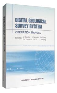
The development, popularization and application of Digital Geological Mapping System are organized by China Geological Survey. It has been widely used in national geological survey since 2004. Now digital mapping system is still in research and development. Digital regional geological mapping system is the software for whole process of regional geological mapping survey. The functions of this software include the navigation and positioning of BEIDOU and GPS, electronic compass measure, sketch compiling, the field data captured from geological route observation, practical measured profile, geochemical rock survey, geochemical soil survey, geochemical stream sediment survey and heavy placer survey,as well as making geological map, 3D geological map modeling and spatial geological map database establishing. Base on the logical data layer model, the technology of data stream "pool", the inherited technology of data model in different work flow interoperable data and 3S technology, etc, the seamless integrative technology on digital regional geological mapping system from field data capture to geological map or 3D geological map display not only diminish the difficulty for the use of high technology, but also provide the useful tools to geologists. The precision and efficiency of this system have been greatly improved. The production expression has been enriched. The digital regional geological mapping system has been become as the most currency software in the geological survey in China with its application.
数字地质调查系统操作手册 目录
- >
随园食单
随园食单
¥15.4¥48.0 - >
名家带你读鲁迅:朝花夕拾
名家带你读鲁迅:朝花夕拾
¥10.5¥21.0 - >
烟与镜
烟与镜
¥14.4¥48.0 - >
我从未如此眷恋人间
我从未如此眷恋人间
¥32.4¥49.8 - >
苦雨斋序跋文-周作人自编集
苦雨斋序跋文-周作人自编集
¥6.9¥16.0 - >
唐代进士录
唐代进士录
¥15.1¥39.8 - >
推拿
推拿
¥12.2¥32.0 - >
新文学天穹两巨星--鲁迅与胡适/红烛学术丛书(红烛学术丛书)
新文学天穹两巨星--鲁迅与胡适/红烛学术丛书(红烛学术丛书)
¥9.9¥23.0
-
煤矿生产组织管理
¥26¥28 -
(高职高专)轧钢设备维护与检修(第2版)
¥43.5¥59 -
简明铸铁熔炼手册
¥94.6¥169 -
4.23文创礼盒A款--“作家言我精神状态”
¥42.3¥206 -
4.23文创礼盒B款--“作家言我精神状态”
¥42.3¥206 -
一句顶一万句 (印签版)
¥40.4¥68


