-
>
湖南省志(1978-2002)?铁路志
-
>
公路车宝典(ZINN的公路车维修与保养秘籍)
-
>
晶体管电路设计(下)
-
>
基于个性化设计策略的智能交通系统关键技术
-
>
德国克虏伯与晚清火:贸易与仿制模式下的技术转移
-
>
花样百出:贵州少数民族图案填色
-
>
识木:全球220种木材图鉴
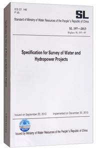
水利水电工程测量规范:英文版 版权信息
- ISBN:9787517056690
- 条形码:9787517056690 ; 978-7-5170-5669-0
- 装帧:一般胶版纸
- 册数:暂无
- 重量:暂无
- 所属分类:>
水利水电工程测量规范:英文版 内容简介
China Water Conservancy and Hydropower Investigation and Design Association (CWHIDA) is a non-profit and national-wide self-regulatory organization under the administration of the Ministry of Water Resources of the People's Republic of China. CWHID has members including Class A and major B companies and institutes in the China water conservancy and hydropower investigation and design industry. In order to satisfy the increasing market demand from international water conservancy and hydropower engineering construction, CWHIDA formulated Translation Plan of Technical Standards 2015-2017 and organized some of its members to translate some investigation and design standards from Chinese to English. Translation of the SL 197-2013 Code for Surveying of Water Resources and Hydropower Engineering was undertaken by the Water Resources and Hydropower Planning and Design General Institute, MWR, under the sponsorship of the CWHIDA.
水利水电工程测量规范:英文版 目录
Foreword
1 General Provisions
2 Terms and Symbols
2.1 Terms
2.2 Symbols
3 Basic Requirements
4 Horizontal Control Survey
4.1 General Requirements
4.2 GNSS Survey
4.3 Triangular Network Survey
4.4 Traverse Survey
4.5 Relevant Data Compilation and Submission
5 Vertical Control Survey
5.1 General Provisions
5.2 Site Selection and Monumentation
5.3 Leveling
5.4 Trigonometric Leveling with EDM
5.5 GNSS Vertical Survey
5.6 Relevant Data Compilation and Submission
6 Digital Topographic Map Surveying
6.1 General Provisions
6.2 Digital Mapping
6.3 Digital Topographic Map
6.4 Topographic Map Revision
6.5 Topographic Map of Check
6.6 Document and Data Compilation
7 Aerial and Space Photogrammetry
7.1 GeneralRequirements
7.2 Photo Control Point Design
7.3 Measurement of Photo Control Points
7.4 Annotation
7.5 Aerial Image Scanning
7.6 Digital Aerotriangulation
7.7 DLG Data Collection and Production of Map
7.8 Data Collection and Processing of Digital Elevation Model
7.9 Production of Digital Orthophoto Map
7.10 Airborne LiDAR Scanning Survey
7.11 Unmanned Air Vehicle (UAV) Low-altitude Digital Photogrammetry
7.12 Relevant Data Compilation and Submission
8 Terrestrial Laser Scanning and Terrestrial Photogrammetry
8.1 General Requirements
8.2 Terrestrial Laser Scanning Survey
8.3 Terrestrial Stereo (Multi-baseline) Photogrammetry
8.4 Relevant Data Compilation and Submission
9 Remote Sensing Image Interpretation
9.1 GeneraIRequirements
9.2 Preparation
9.3 Remote Sensing Image Processing
9.4 Establishment of Interpretation Signs
9.5 Remote Sensing Image Interpretation
9.6 Field Verification
9.7 Post Processing of Interpreted Information
10 Map Compilation
11 Special Engineering Survey
12 GIS Development
13 Editing and Warehousing of Spatial Data
14 Acceptance of Achievements and Quality Inspection and Evaluation
Annex A Horizontal Control Survey
Annex B Vertical Control Survey
Annex C Aerial Photogrammetry
Annex D Remote Sensing Image Interpretation
Annex E Special Engineering Survey
Annex F GIS Development
Annex G Product Acceptance and Quality Inspection and Evaluation
水利水电工程测量规范:英文版 作者简介
中华人民共和国水利部, 负责保障水资源的合理开发利用,拟订水利战略规划和政策,起草有关法律法规草案,制定部门规章,组织编制国家确定的重要江河湖泊的流域综合规划、防洪规划等重大水利规划。按规定制定水利工程建设有关制度并组织实施,负责提出水利固定资产投资规模和方向、国家财政性资金安排的意见,按国务院规定权限,审批、核准国家规划内和年度计划规模内固定资产投资项目;提出中央水利建设投资安排建议并组织实施。 负责生活、生产经营和生态环境用水的统筹兼顾和保障。实施水资源的统一监督管理,拟订全国和跨省、自治区、直辖市水中长期供求规划、水量分配方案并监督实施,组织开展水资源调查评价工作,按规定开展水能资源调查工作,负责重要流域、区域以及重大调水工程的水资源调度,组织实施取水许可、水资源有偿使用制度和水资源论证、防洪论证制度。指导水利行业供水和乡镇供水工作。
- >
名家带你读鲁迅:故事新编
名家带你读鲁迅:故事新编
¥13.0¥26.0 - >
山海经
山海经
¥17.7¥68.0 - >
【精装绘本】画给孩子的中国神话
【精装绘本】画给孩子的中国神话
¥17.6¥55.0 - >
我从未如此眷恋人间
我从未如此眷恋人间
¥32.4¥49.8 - >
大红狗在马戏团-大红狗克里弗-助人
大红狗在马戏团-大红狗克里弗-助人
¥3.5¥10.0 - >
罗曼·罗兰读书随笔-精装
罗曼·罗兰读书随笔-精装
¥20.3¥58.0 - >
罗庸西南联大授课录
罗庸西南联大授课录
¥13.8¥32.0 - >
伊索寓言-世界文学名著典藏-全译本
伊索寓言-世界文学名著典藏-全译本
¥9.3¥19.0
-
水利史话
¥14.3¥15 -
中国文化知识读本:古代水利工程
¥13.1¥34.8 -
4.23文创礼盒A款--“作家言我精神状态”
¥42.3¥206 -
4.23文创礼盒B款--“作家言我精神状态”
¥42.3¥206 -
一句顶一万句 (印签版)
¥40.4¥68 -
百年书评史散论
¥14.9¥38


